US 50 Emergency Bridge Improvements

Announcements

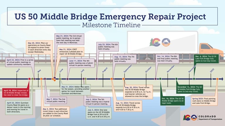
CDOT invites you to an upcoming hybrid public meeting regarding the US 50 Blue Mesa Bridge Closure west of Gunnison. Members of CDOT’s leadership team, Kiewit and representatives from Gunnison County will be attending in person to provide the latest information regarding the upcoming limited bridge opening operational plan. Folks will also be able to listen online and ask questions. Spanish and ASL interpretation will be available.

When: Tuesday, July 2, 2024 at 6:30 to 8 p.m.

Where: Gunnison Courthouse 200 E Virginia Ave, Gunnison, CO 81230; 2nd floor Elevator access available

Link to Join Virtually: bit.ly/BlueMesaBridge

Lake Fork Bridge Lane Closures

There will be single-lane closures on the Lake Fork Bridge, just west of Sapinero, Friday, June 28, through Monday, July 1, from 7 a.m. to 5 p.m. each day to install strain gauge sensors. These sensors will monitor the effect of traffic loading on the bridge and will be used to analyze the effects of construction activities as crews move into the inspection and repair phases on this bridge.

About the Project:

US 50 bridge crossing the Blue Mesa ReservoirUS 50 bridge crossing the Blue Mesa Reservoir near Dillon Pinnacles that is now closed

A safety closure is in place for a bridge on US Highway 50 located west of Gunnison. The Colorado Department of Transportation has closed the bridge at the urging of the
Federal Highway Administration and state bridge engineering experts due to the findings of an ongoing safety inspection, which identified anomalies in the bridge on Thursday, April 18. The closure is in place between US 50 Mile Point 136 and MP 140. Motorists should use COtrip.org to plan an alternate route. There is currently no estimated time for reopening as of Thursday, May 16. Updates will be made to this website once an estimate is available.

 Detour Route of US 50 & Closures on COtrip

Project Facts

  • Construction Cost: $6 Million
  • Contractor: Kiewit
  • Timeline: April 2024 to August 2024
  • Location: US 50 eastbound and westbound
    • Nearest Town/City: Gunnison
    • Mile Point(s): 137.30 to 137.31
    • County: Hinsdale, Gunnison, and Montrose counties
Map depicting closure locations on US 50 west of Gunnison US 50 map showing the road is closed in both directions from Mile Point 136 to 140 


Traffic Impacts

Recommended Alternate Routes for US 50 

This closure will create a significant detour for commuters between Montrose and Gunnison. The recommended detour route for through traffic is via I-70 to the north or US 160 to the south. Access the recommended detour route on COtrip here. CDOT understands the inconvenience that this creates and is rapidly evaluating options to improve options for residents, businesses, and travelers on the western slope.

The northern route is 354 miles and requires approximately six hours of travel time. The southern route is 331 miles and requires nearly seven hours of travel time. CDOT and local partners are exploring whether it is feasible at this point in the season to clear local seasonal routes that may be able to significantly reduce the detour time for local travelers.

Local Access Route Information


Key Facts:

  • CDOT has been conducting a special inspection for high-strength steel bridges for the Blue Mesa bridges as required by the Federal Highway Administration. This inspection was required because of known issues with similarly constructed bridges elsewhere in the country. A defect was observed during an early investigation of the bridge at approximately Mile Point 136.3. CDOT immediately brought in a second inspection crew with resources to perform another method for testing whether the defect posed a safety hazard on the bridge. The second inspection took place on Thursday, April 18.
  • CDOT is continuing to assess the safety of the bridge and to quickly determine options for interim and permanent fixes – and will keep the public informed as soon as more information is available. The bridge closure is located between Gunnison and Montrose. It is located east of the US 50 Little Blue Creek Canyon project, which is currently in a planned winter shutdown.
  • Once our inspection plans are finalized and we can more accurately forecast a time frame to complete that work, we will be able to follow up with additional information for the public about the duration of this closure. As more of the inspection work is complete, we will also have more details to share about the condition of the bridges, as well as any restrictions that will need to remain in place while repairs are made.

Work Schedule:

More information coming soon.