Public Involvement
Community Engagement
CDOT is committed to fostering open communication and collaboration with stakeholders and community members throughout the project. Engaging the public ensures that diverse perspectives are considered in decision-making, helping to shape the project in a way that reflects community needs and values.
Stakeholder and Community
To ensure a collaborative and inclusive approach, CDOT has organized a series of workshops, focus groups, and community outreach initiatives to gather valuable input and feedback on project options and impacts.
Alternatives Design and Evaluation Workshops
- Winter 2022: Ultimate Vision Workshop
- Spring 2022: Alternatives Workshop
- Summer 2022: Bike-Pedestrian Charrette
Stakeholder Focus Group (SFG)
The SFG gathers input from local entities (businesses, nonprofits, schools, etc.) and neighborhood groups (RNOs) regarding project options and impacts.
- Winter 2021: Project Introduction
- Summer 2024: Overview of Public Input & Next Steps
- October 2024: Project Process Update, Traffic Evaluation and Next Steps with a Concept Workshopping Activity
- July 2025: Alternatives Screening Process & Results
Denver City Council Briefings
CDOT has engaged with Denver City Council members through a series of meetings to provide updates and gather feedback on the PEL and the I-25: Speer & 23rd Bridge & Interchange Projects.
- Fall/Winter 2021
- Spring 2022
- Summer 2025
Community Survey 2022
The I-25: Speer & 23rd Bridge and Interchange Project Community Survey was conducted to understand community interests and concerns. Respondents shared their experiences using the corridor and suggested improvements.
29th Street Slower & Safer Street Meeting
- Summer 2024
Bike-to-Work Events
- Winter 2022
- Summer 2024
23rd Avenue Stakeholders Meetings and Workshops
In response to interest in the alternatives evaluation process, CDOT conducted a series of meetings with a self-formed Stakeholder Coalition representing various local entities.
Public Meetings
The Colorado Department of Transportation hosted a public open house in August 2025. The public meeting covered the following items:
- Recap of Initial Alternatives and Public Involvement
- Results of Alternatives Evaluation and Refinements
- Recommended alternative(s) to advance into NEPA, based on technical and public input
- Bike and pedestrian facilities for recommended alternative(s)
Access the open house information and resources below:
Download August 2025 Public Open House Meeting Boards in English
Download August 2025 Public Open House Meeting Boards in Spanis
A public open house was held on April 8, 2024 at the Colorado Department of Transportation Headquarters located at 2829 West Howard Place in Denver, CO 80204. Access meeting boards by clicking the button below.
- In-Person Public Meeting: Held on April 8 at CDOT Headquarters to discuss the project and gather feedback on design alternatives
- Online Public Meeting: Available for one month following the in-person meeting, allowing community members to access information and provide feedback
Go to the April 2024 Public Open House section below to access meeting materials and resources.
Meeting Resources
April 2024 Public Open House Survey
The collapsible panels below contain the same information shared during the Public Open House on April 8, 2024. Select any of the panel titles below to access the meeting boards.CDOT launched the I-25: Speer Boulevard and 23rd Avenue Bridge and Interchange project during the Summer of 2021 to study and evaluate replacing the bridges that cross over I-25 in Central Denver. These bridges are near the end of their useful life and are often struck by trucks due to deficient vertical clearance. They are in need of replacement for the safety of all travelers.
This project seeks to:
- Improve operations and safety for vehicles
- Improve facilities for bikes and pedestrians
Study Area Map
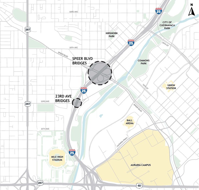
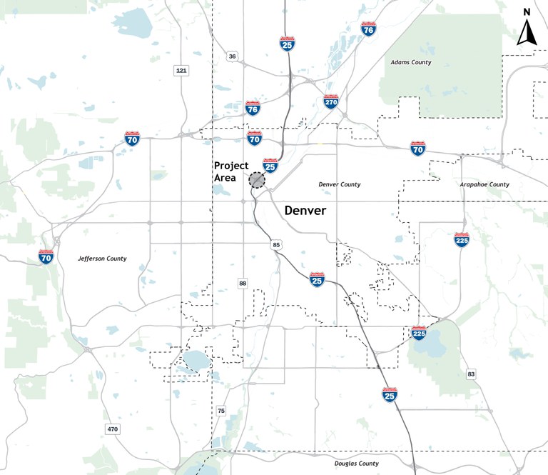
I-25 Central PEL
The I-25: Speer Boulevard and 23rd Avenue Bridge and Interchange Project was identified in the I-25 Central Planning and Environmental Linkages Study (PEL) as a first step for CDOT to improve the transportation infrastructure. Select the button below to learn more about the I-25 Central PEL.
Visit I-25 Central PEL Findings
Other Related Projects & Studies
Several projects and studies have been conducted in the area by the City and County of Denver, CDOT, and other organizations. The project team has reviewed these projects and studies and is developing alternatives that are consistent with them. Review the list of those projects and studies below.
Explore Related Projects & Studies
Ongoing Public Involvement
Throughout the study process, public feedback will be gathered on the alternatives under consideration. The project team has already engaged with several community stakeholder groups, conducted a community survey and distributed informational fliers at a Bike to Work Day event in June of 2023. If there is a stakeholder group we should reach out to, please let us know.
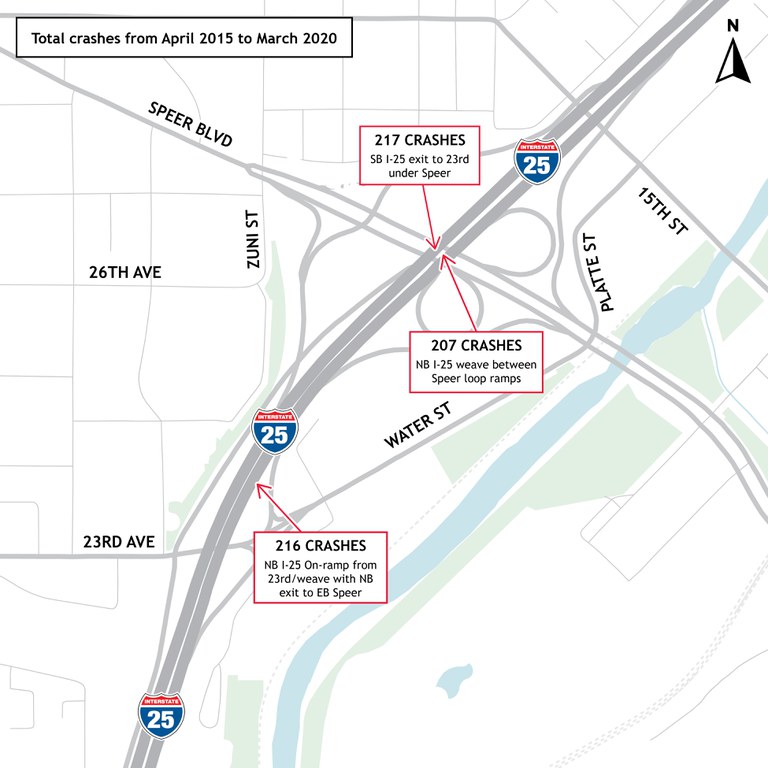
The project team gathered existing-conditions data on transportation infrastructure, vehicle crashes, bike and pedestrian fatalities, and on the height or vertical clearance of the Speer Boulevard and 23rd Avenue bridges over I-25. This information helps to create solutions that improve transportation in this area.
Vehicular Crashes
This section of I-25 (from Colfax Avenue to 20th Street) experiences about 38 percent more crashes and 54 percent more fatal and injury crashes than what would be expected on similar facilities.
Bike & Pedestrian Facilities
In the existing condition there are no bike or pedestrian facilities on the north side of Speer Boulevard and on the south side of 23rd Avenue. The lack of these facilities leaves connectivity gaps in the bike and pedestrian infrastructure.

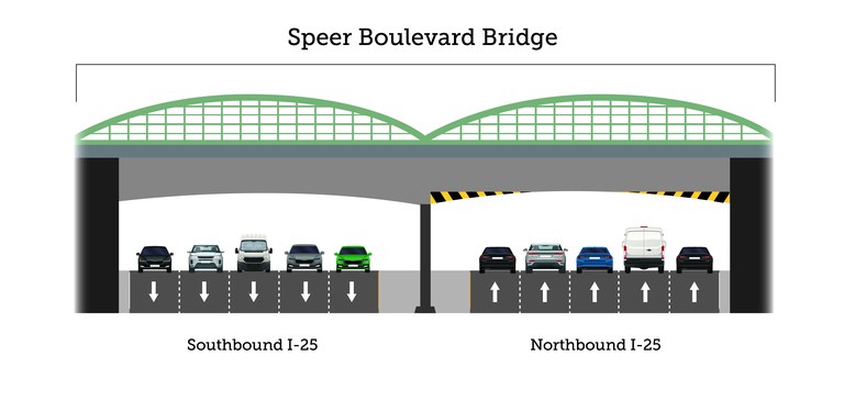
Minimum Vertical Clearance (Bridge Height over I-25)
CDOT’s standard for bridge height is 16-foot six inches. The clearance for the 23rd Avenue bridge over I-25 ranges from 12 feet, 11 inches at the lowest points to 16 feet, one inch at the highest point.
The clearance for the Speer Boulevard bridge ranges from 12 feet, five inches at the lowest points to 16 feet, nine inches at the highest point.
This photo below shows the Speer Boulevard bridge. The missing concrete and exposed rebar is the result of a truck traveling on I-25 and striking the bridge.


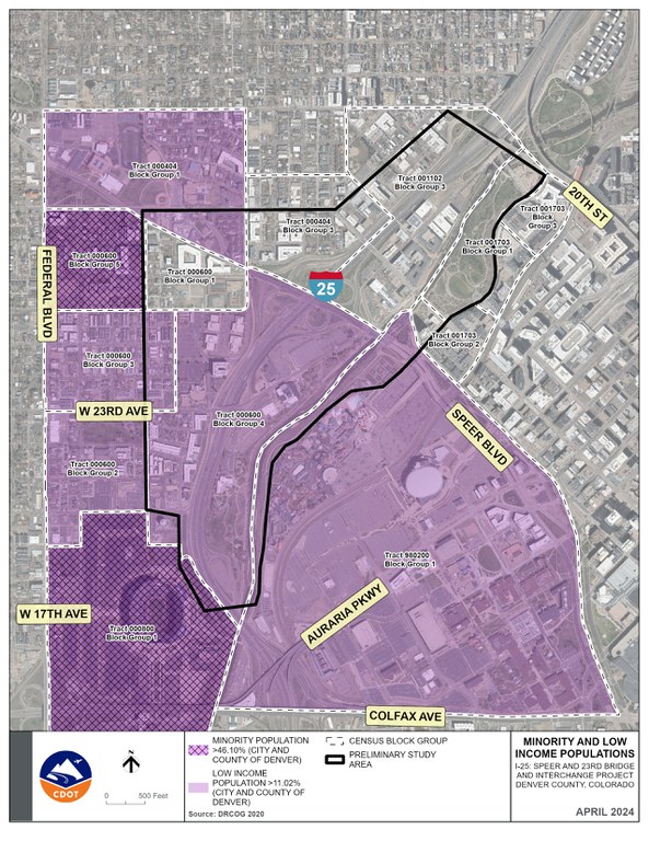
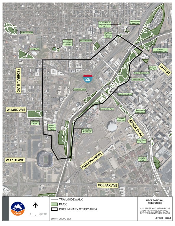
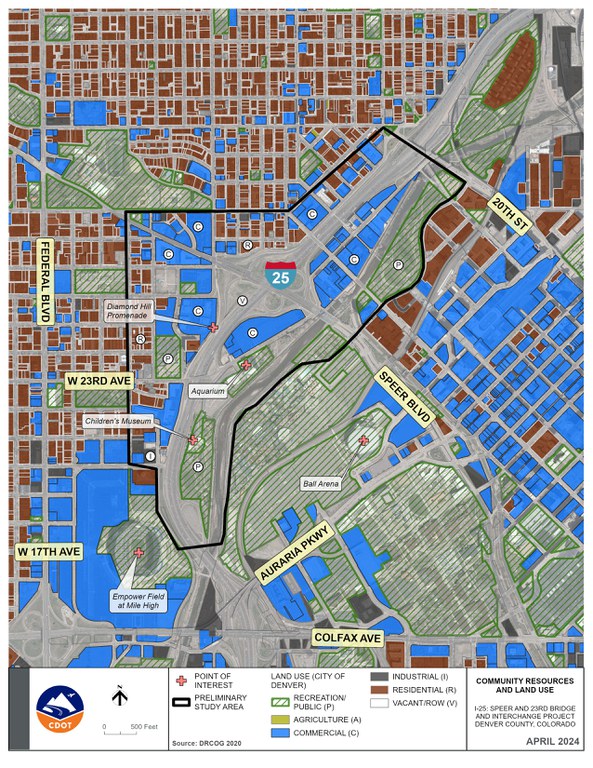
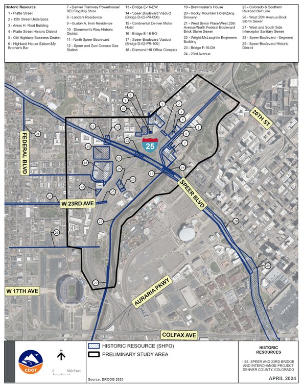
The project team has begun to collect environmental existing conditions data including residential demographics to identify minority and low income populations, recreational resources, historic properties, and community resources. Navigate the graphics below to access these resources. The project team is also aware that the project is within a City and County of Denver protected view plane.
National Environmental Policy Act (NEPA) analysis
During future National Environmental Policy Act (NEPA) analysis, other existing conditions and potential project impacts will be evaluated for:
- Air quality and greenhouse gas emissions
- Water quality
- Floodplains
- Waters of the U.S., including wetlands
- Environmental justice
- Land use
- Biological resources (wildlife, fisheries)
- Threatened, endangered, and state special status species
- Noxious weeds
- Hazardous materials
- Cultural resources (historic and archeological)
- Paleontological resources
- Noise
- Visual resources
- Recreational resources
- Secondary and cumulative impacts
Minority and Low Income Populations
Recreational Resources
Community Resources and Land Use
Historic Resources
Alternative Development and Screening
In this current phase, we create design options to address the Purpose and Need. The project will evaluate these alternatives against screening criteria.
NEPA Analysis
NEPA requires that projects using federal funds, requiring a federal permit or linked to a federal action analyze effects on the natural and social environment. Since CDOT is using federal funding for this project, once a recommended alternative(s), including the No Action, are selected, the project will go through NEPA review and documentation.
The public involvement process shall continue during NEPA. CDOT and FHWA will select an alternative at the conclusion of the NEPA process. The document will also disclose impacts, necessary permits, and mitigation of those impacts for the selected alternative.
The project will undergo CDOT's Procedural Directive 1601 Process for Interchange Improvements following NEPA and before final design. Following this process, final engineering design, potential right of way acquisition, and construction could occur if a Build Alternative is selected.
The area around the Speer Boulevard and 23rd Avenue Bridge and Interchange Project is undergoing changes, including Empower Field at Mile High Stadium, Ball Arena, Elitch Gardens, Speer Boulevard, and along the South Platte River. The project is taking these developments into consideration during the evaluation of alternatives and the future NEPA process.
- River Mile: Rive Mile is a mixed-use development connecting the urban environment to the natural environment. River Mile will incorporate residential, commercial, and business development to create a “new kind of downtown” experience in Denver.
- KSE Ball Arena Vision Plan: KSE Ball Arena Vision Plan is a mixed-use neighborhood made accessible to the entire city, including plans to offer improved connections across Speer Boulevard, Auraria Parkway, and the Light Rail line. The emphasis is on multimodal transportation and livable streets.
- Diamond Hill Redevelopment: The Diamond Hill Redevelopment is a 10.5-acres site for mixed-used development. One-thousand residential units and two office buildings are proposed and will allow up to 12 stories.
- Cherry Creek & Speer Boulevard Vision Study: The Cherry Creek and Speer Boulevard Vision Study will improve how people move through Speer Boulevard and Cherry Creek Trail between Colfax Avenue and I-25. The study focuses on environmental, public space, and recreational, cultural, connectivity, inclusivity ,commerce and education elements. The study builds off the Urban Land Institute Technical Advisory Panel Report.
Finalizing Purpose & Need
The team will review any public input received and finalize the Purpose & Need Statement.
Screening and Refining Alternatives
The project team will combine technical evaluation and community input to screen out draft alternatives that do not sufficiently meet Purpose & Need and refine the remaining alternatives for more detailed evaluation.
Next Public Meeting
Another public meeting is planned for early 2025. That public meeting will:
- Show alternative(s) that are recommended to advance into NEPA, based on technical and public input
- Show bike and pedestrian facilities for recommended alternative(s)
