I-70 Floyd Hill Project | Construction
Project Updates/Announcements
Expect I-70 traffic holds for rock blasting through 2026. Sign up for text alerts to stay informed by texting floydhill (one word) to 21000. For more information, please access the Rock Scaling/Blasting Frequently Asked Questions.
About the Project
The I-70 Floyd Hill Project encompasses an eight-mile section of the I-70 Mountain Corridor from west of Evergreen to eastern Idaho Springs that acts as an economic gateway for the state of Colorado and the nation. Home to long-time residents, dozens of large and small businesses and tourism traffic, this section of I-70 is in desperate need of improvements.
Adjusted Estimated Project Cost
In 2020, the estimated Project cost was $700 million based on a preliminary conceptual design. As design progressed toward final, more Project details became known. Since 2020, the transportation industry faced cost pressures such as rising construction and material costs, which directly impacted the I-70 Floyd Hill Project. The 2025 cost to deliver the Project as scoped is now $905 million.
Westbound I-70 will be in its new alignment by the end of 2027 and eastbound I-70 will be in its new alignment by the end of 2028, with the entire Project complete in 2029. The adjusted completion date, extending from 2028 to 2029, provides the Project team with additional time to refine the design and timeline to address seasonal environmental constraints.
Work this Week & Lane Closures I-70 Floyd Hill
Project Facts
- Estimated Construction Cost: $905 million (Refer to Adjusted Estimated Project Cost for details)
- Contractor: Kraemer North America
- Timeline: Construction began in July 2023. I-70 will be in its new alignment in 2028, with the entire Project complete in 2029. (Refer to Adjusted Project Timeline for details)
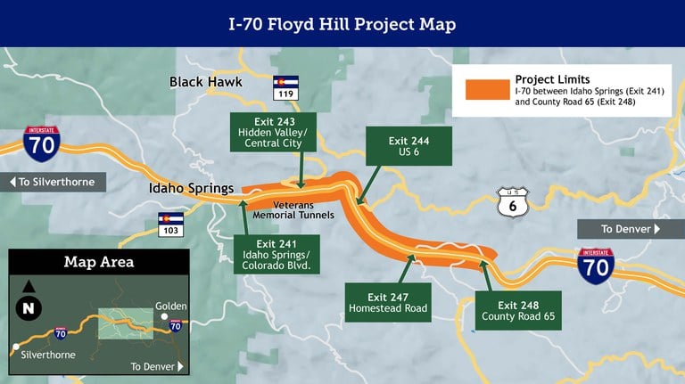
- Location: I-70 from County Road 65 (Exit 248) to Colorado Boulevard (Exit 241)
- Nearest Town: Idaho Springs
- Mile Points: 241 to 248
- County: Clear Creek County
I-70 Floyd Hill Project Map

The I-70 Floyd Hill Project will:
- Add a third westbound I-70 travel lane in this two-lane bottleneck to improve travel time reliability. This new lane will be a full-time, tolled Express Lane from just west of Homestead Road (Exit 247) to Colorado Blvd./Idaho Springs (Exit 241).
- Change the alignment of I-70 from the middle of Floyd Hill to the Veterans Memorial Tunnels to straighten roadway curves, which will improve safety and sight distance.
- Rebuild bridges due to heavy usage and wear and tear.
- Add a two-mile section of frontage road between the US 6 and Hidden Valley/Central City Parkway interchanges, which will improve resiliency and emergency response.
- Move the current left-merge US 6 on-ramp to westbound I-70 to the Hidden Valley/Central City Parkway (Exit 243) interchange to improve safety and operations.
- Build an extended on-ramp from US 6 onto eastbound I-70 to give slow-moving vehicles more room to merge.
- Improve traffic flow at interchanges and intersections by adding roundabouts on US 40 at County Road 65 (Exit 248) and Homestead Road (Exit 247), and at the I-70 and Hidden Valley/Central City Parkway (Exit 243) interchange.
- Improve the Clear Creek Greenway trail and resurface it with concrete.
- Implement environmental mitigation to enhance wildlife connectivity, air and water quality, stream conditions and recreation.
- Install two permanent air quality monitors.
Future I-70 Floyd Hill
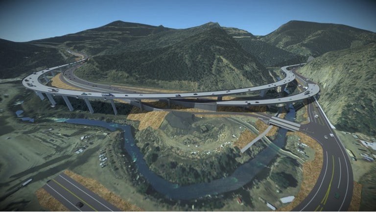
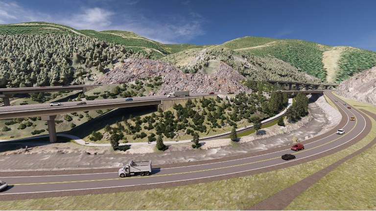
Explore design renderings of the I-70 Floyd Hill Project. Major Project elements pictured below depict the following:
- New westbound I-70 Express Lane being built between west of Homestead Road (Exit 247) to Colorado Boulevard/Idaho Springs (Exit 241)
- New 115-foot tall bridge that will carry westbound I-70 traffic in a new alignment that shifts the highway south into the hillside above Clear Creek
- Braided configuration of eastbound and westbound I-70
- New frontage road connecting US 6 to the Hidden Valley/Central City Parkway (Exit 243) interchange
Check all design renderings in the I-70 Floyd Hill project photos.


