Colorado Mountain Rail | Preliminary Design & Planning

About the Project

The Colorado Department of Transportation (CDOT) is exploring a new initiative to enhance transportation options in the central Rocky Mountains. The plan involves developing a network of passenger rail lines that connect the mountain towns and regions with urban centers and recreational locations. This project aims to use existing rail infrastructure to meet the growing demand for passenger rail service.

Project Area

The Mountain Rail route will use the existing rail line that extends from Denver to Craig. The specific station locations along the new route are still under consideration. CDOT is currently evaluating multiple factors to identify the most suitable sites for these stations. As a part of this ongoing study, community feedback is crucial in shaping the final decisions. This input will be integrated with engineering requirements and design constraints to ensure the selected station locations meet both practical and community needs.
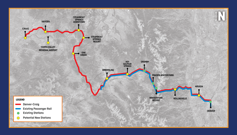
Colorado Mountain Passenger Rail Project Map

Schedule & Important Dates

There are no upcoming dates at this time.

Launched in 2023, the Mountain Rail Program is a part of CDOT’s Division of Transit and Rail’s Passenger Rail Branch. This small but dedicated team is focused on bringing passenger rail service to both the Front Range and the mountain regions of Colorado. The program was established in response to requests from state legislators and communities like Steamboat Springs and Winter Park. A shift in the rail industry, with declining coal traffic, has opened opportunities to repurpose rail corridors for passenger use.

In October 2023, the Colorado Transportation Commission approved initial funding to develop a service plan for this vision.

Given the popularity of travel in the mountains and challenging geographical conditions, it is critical to provide reliable transportation alternatives to create better connectivity to mountain towns, recreational opportunities, and transitional communities. The Mountain Rail project would provide alternative transportation options for visitors who want to experience mountain towns but who do not want to drive. Additionally, it would promote economic development, as housing, hotels, and retail establishments become attracted to areas served by rail.

Open House Materials:

Overall Station Map
Existing and potential station locations for inclusion within the Preliminary Service Development Plan (SDP), including proposed rail service.

Map of proposed rail service from Kremmling to Rollinsville
Fraser Valley meeting close up map of existing and potential station locations for inclusion within the Preliminary Service Development Plan of proposed rail service from Kremmling to Rollinsville

Map of proposed rail service from Craig to Kremmling
Yampa Valley meeting close up map of existing and potential station locations for inclusion withing the Preliminary Service Development Plan of proposed rail service from Craig to Kremmling
Mountain Rail Phasing Map
Potential Mountain Rail phasing map from Denver to Craig, including the existing passenger rail and stations, and potential new stations.

Map of proposed rail service from Rollinsville to Union
Denver Metro Meeting close up map of the existing and potential station locations for inclusion within the Preliminary Service Development Plan and proposed rail service from Rollinsville to Union

Map of proposed service pattern alternatives from Craig to Denver
Service pattern alternatives map depicting existing and proposed stations from Craig to Denver, including long pattern from Craig to Denver, short pattern from Granby to Denver and commute pattern from Craig to Oak Creek

Open House Materials:


Close-up map of proposed train station site in Craig, located on Yampa Avenue

Close-up map of potential train station sites in Steamboat Springs, highlighting the Downtown and Resort Station areas

Close-up map of potential train station site in Kremmling, located south of Depot Avenue

Close-up map of potential train station sites in Granby, located south of East Agate Avenue, Highway 40

Close-up map of potential train station site in Winter Park Resort, located west of Winter Park Drive
Close-up map of proposed train station site in Hayden, located on North Poplar Street south of West Iron Horse Road

Close-up map of potential train station site in Oak Creek, located north of Nancy Crawford Boulevard, between Sharp Avenue and Bell Avenue

Close-up map of potential train station site in Hot Sulphur Springs, located north of Spring Road

Close-up map of potential train station site in Fraser, located west of Zerex Street, Highway 40