CO 67 Widening in Woodland Park
About the Project
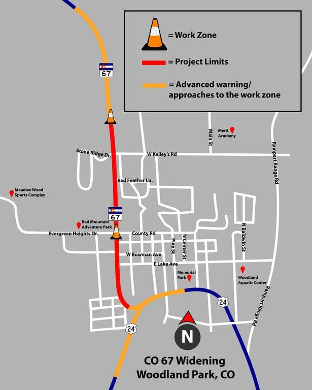
The project consists of widening and making mobility and safety improvements to a section of Colorado Highway 67 in Woodland Park northwest of Colorado Springs. Work includes widening CO 67 from County Road (Evergreen Heights Drive) to West Kelley’s Road from two to four lanes with a shared turn lane. Other work sitewide includes:
- Building raised medians near major intersections
- Installing new pedestrian facilities
- Adding signal heads to West Kelley’s Road
- Making drainage and safety improvements
Work this Week & Lane Closures on CO 67 in Woodland Park
Project Facts
- Construction Cost: $7.2 Million
- Contractor: Capital Paving & Construction
- Timeline: March 2025 to October 2025 (includes pre-construction tree removal)
- Location: CO 67 from US 24 junction to north of West Kelley's Road
- Nearest Town/City: Woodland Park
- Mile Point(s): MP 76.92 to MP 79.21
- County: Teller

Project Benefits
- Increase capacity by widening the highway to four lanes, with a shared turn lane
- Improve safety by adding medians and signals at various intersections
- Enhance mobility and accessibility to all modes of transportation
Work Schedule
- Work began in mid-March and is expected to last until October
- Project hours will be split between two shifts: from 7 p.m. to 5 a.m. Sunday to Thursday and 7 a.m. to 7 p.m. Monday to Friday
Traffic Impacts
Motorists can expect the following impacts during the period of construction:
- As of April 8, a new lane alignment exists within the project limits and caution is advised
- Daytime lane closures will exist on CO 67 Monday to Friday from 8:15 a.m. to 3:15 p.m. followed by shoulder and/or acceleration/deceleration lane closures, as needed
- Speeds are reduced to 35 MPH until Oct. 31, 2025
- Single lane closures in both directions of CO 67 from the US 24 junction to County Road/Evergreen Heights Drive will be in place Sunday to Saturday
- Single overnight lane closures in both directions of CO 67 (between County Road/Evergreen Heights Drive) and 900 feet north of West Kelley’s Road from Sunday to Thursday that will be managed by flaggers
- Overnight single lane closures can also be expected in both directions of US 24 at the approaches to the work zone, managed by flagger operations
- A full closure of Stone Ridge Drive at Ptarmigan Drive may occur during certain work activities, with detour from Millstone Lane to Research Boulevard posted
- Reduced entrances at side streets, area communities and businesses with access maintained
- Uniformed traffic control personnel and/or flaggers onsite during certain work activities
- 11-foot width restriction
- Signs and construction devices present to manage traffic flows
- Refer to COtrip.org for real-time travel conditions and road closures
