CO 119 Safety, Mobility and Bikeway Project - Design
Design
By the year 2040, the Diagonal Highway between Boulder and Longmont is expected to see a 25% increase in vehicular traffic. Increased traffic can result in more congestion, delay, tailpipe emissions, and potentially more crashes. The Colorado Department of Transportation (CDOT), the Regional Transportation District (RTD), and Boulder County are taking action to mitigate these outcomes and expand transportation options beyond private automobiles.
The CO 119 Safety, Mobility and Bikeway Improvements Project, a joint project between CDOT, RTD and Boulder County, is designing improvements to make traveling through the corridor safer for all modes and transit travel faster and more reliable. The project is designed to integrate with other active multimodal projects on the corridor to ensure community members can safely and reliably travel throughout the corridor using their mode(s) of choice. Funding has been secured for implementation of the CO 119 Safety, Mobility and Bikeway Improvements Project, which is expected to go to bid for construction in fall 2023.
Updates
- RAISE 2023 Awardee!
CO 119 corridor partners received $25 million in funding to construct multimodal improvements at CO 119 and Hover Street.
Visit USDOT announcement to learn more.
The RAISE 2023 Fact Sheet can be viewed here.
Project Area
- Colorado Highway 119 (CO 119) between Boulder and Longmont. This corridor is commonly referred to as “The Diagonal.”
- Southern limit is Foothills Parkway in Boulder and northern limit is Hover Street in Longmont.
- While the project limits do not extend beyond Foothills Parkway or Hover Street, the proposed Bus Rapid Transit routes extend beyond the corridor from downtown Boulder to Colorado Highway 66 north of Longmont.
A 1041 Permit is required before construction can begin, visit 1041 Permit to learn more.
Project Improvements
- New signage, striping, and improved signal timing at all pedestrian crossings.
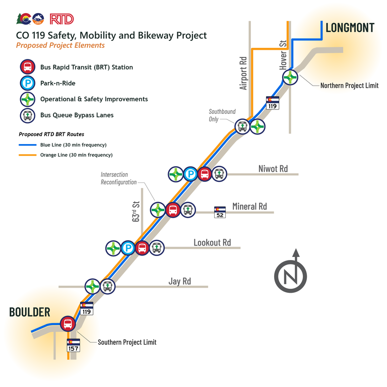
- Signal timing adjustments at key intersections (Jay Road, 63rd Street, CO 52, Niwot Road, and Airport Road).
- Physically reconfiguring the CO 52 intersection to improve safety and to accommodate new Bus Rapid Transit (BRT) stations and Boulder County’s Commuter Bikeway between the northbound and southbound roadways.
- Changing access at Airport Road and CO 119 to reduce crashes and to improve safety and traffic flow.
- Hover Street intersection will be improved through a separate project.
- BRT improvements:
- Park-n-Rides at 63rd Street and Niwot Road.
- Within the project limits, new BRT stations at 63rd Street, CO 52, and Niwot Road.
- Queue Bypass Lanes at Jay Road, 63rd Street, CO 52, Niwot Road, and Airport Road
- The BRT routes proposed for the corridor are the Blue Line and the Orange Line, both of which run every 30 minutes. A list of all stops associated with the proposed BRT service is available here.

- Improve safety in the whole corridor
- Maximize the number of people able to move through the corridor
- Maximize intersection operational efficiency
- Improve transit travel times and increase ridership
- Maximize corridor-wide operational efficiency
- Increase opportunities for bicycle commuting and connectivity to the bicycle and pedestrian network
- Vehicles can move through the corridor faster, with shorter wait times at traffic lights, resulting in less fender benders and crashes
- Traveling the corridor by bus will take about half the time it currently does
- More frequent bus service supports greater travel flexibility
- Safer and more comfortable experience accessing the corridor on foot
- Integration between Bus Rapid Transit, Park-n-Rides, pedestrian crossings, and Boulder County’s Commuter Bikeway enables commuters to switch travel modes safely and reliably
