CO 12 Southern Mountain Loop Planning and Environmental Linkages (PEL) Study
About the Study
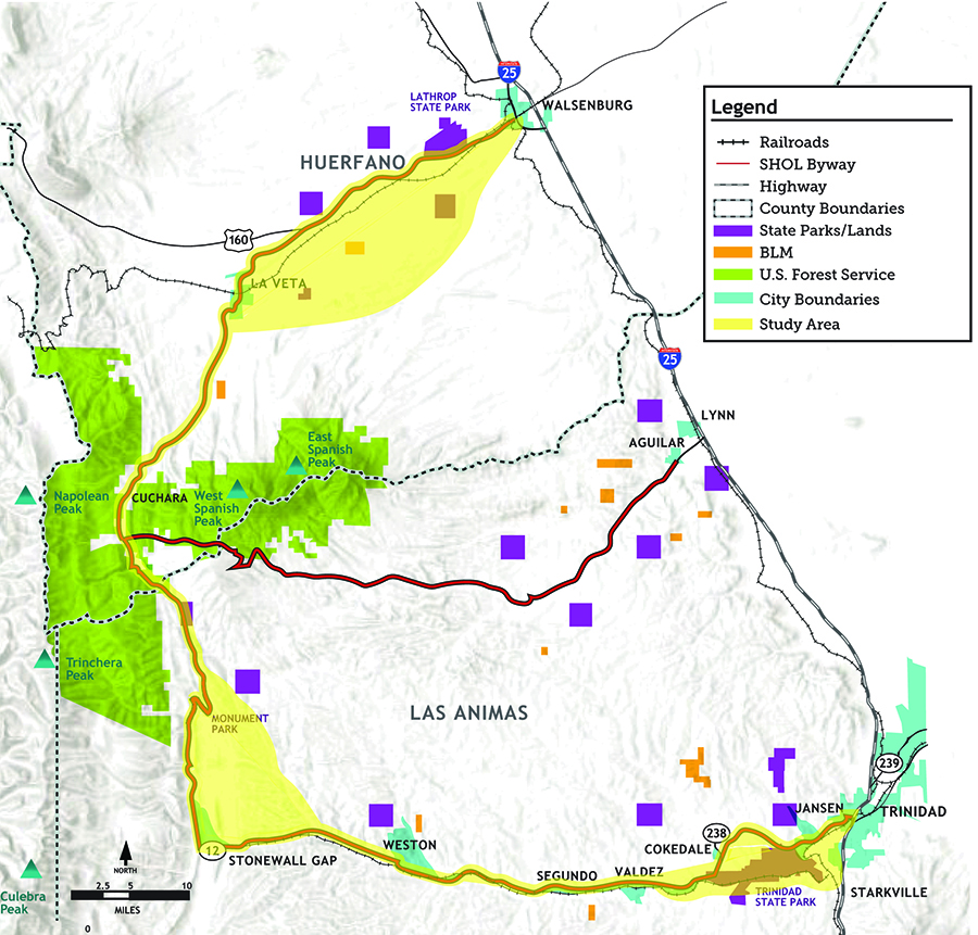
CDOT and the South Central Council of Governments (SCCOG) are conducting a Planning and Environmental Linkages (PEL) Study of the Southern Mountain Loop (SML) of the Colorado Front Range Trail. The SML corridor extends about 82 miles, from Walsenburg to Trinidad along US Highway 160 and Colorado Highway 12. This corridor is also designated as the Scenic Highway of Legends Byway.
This study will examine the following needs for improvements to the corridor, as well as produce conceptual design, funding, scheduling, and phasing recommendations:
- Improve highway, bicyclist, and pedestrian safety throughout the corridor.
- Maintain and rehabilitate the highway's pavement and bridges.
- Provide a regional and local bicycle/recreational trail system along the corridor.
- Improve connections and access to communities and recreational areas along the corridor for all visitors and users.

- Goal: Enhance the two-county region's tourism-related economy through a long-term investment plan for highway safety, bicycle/recreational trail, cultural/heritage, and nature-based tourism infrastructure improvements along the Southern Mountain Loop corridor.
- Location: The Southern Mountain Loop, an approximate-82-mile corridor from Walsenburg to Trinidad along US 160 and CO 12 in Las Animas and Huerfano counties

PEL Process
The PEL study team will work with the public and community stakeholders to identify the various transportation deficiencies and needs along the SML corridor. The goals:
Understand the goals and values of communities along the corridor.
Understand how the transportation system currently functions.
Understand how the transportation system impacts communities.
Understand how the system can be improved now and in the future.
Once these needs are identified, the team will develop a series of alternatives to address them. The team will then evaluate and consider how well these alternatives meet project needs, along with the effects on the communities and environment.
Some of the considerations that the study will address:
- Are there locations with numerous vehicular crashes?
- Are there recurring types of vehicular crashes or patterns of crashes?
- What are other safety concerns along the corridor?
- What kind of highway improvements would address the safety concerns?
- What is the best location and configuration for a regional trail for bicyclists and pedestrians, either along the highway or on a separate alignment?
- How might a trail system better connect communities and provide access to recreational areas along the corridor?
- How would byway-related improvements, such as cultural or scenic pull-offs, provide new attractions for visitors and connect with the trail improvements? The project will look at current conditions and will also consider future conditions along the SML Corridor with respect to:
- Community plans
- Development plans
- Transportation plans
- Trail plans
- Land management plans
- Railroad operations
After the PEL study is complete, CDOT and the local agency SCCOG will have a documented set of projects and an implementation plan, which they will use to identify funding for project design and implementation. The PEL's resulting "set of projects" will serve as a bucket-list of improvements that will be implemented along the SML corridor over time as funding becomes available.
The higher priority locations will likely be implemented first, but the goal is to eventually implement all of the projects identified in the PEL as conditions warrant, and as funding becomes available. This will take many years.
There has been a series of studies to which the PEL will refer. These include:
- Colorado Front Range Trail (CFRT) Master Plan
- Huerfano County Trails Master Plan 2011
- Colorado Byways Master Plan
- Statewide Bicycle and Pedestrian Plan
- City of Trinidad Comprehensive Plan (2017)
Public Meeting Materials
- Sept. 18 Public Meeting PowerPoint Presentation
- Sept. 18 Public Meeting Presentation Boards
For access to this information, please contact the project team.
