CDOT begins constructing US 160 safety improvements March 3 east of Fort Garland
Travel Advisory
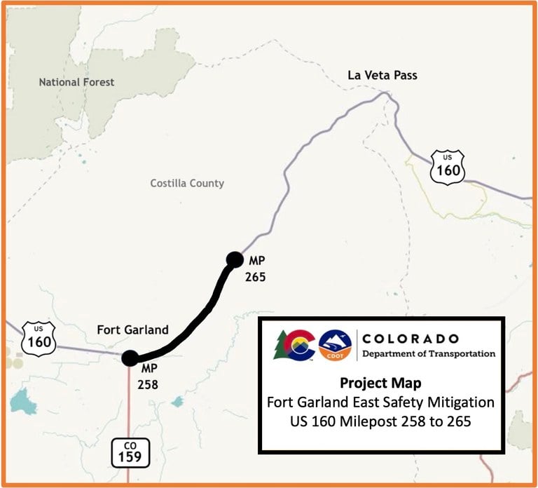
Costilla County — The Colorado Department of Transportation, in partnership with Capital Paving and Construction, will begin construction on the US Highway 160 Fort Garland east safety mitigation project on March 3. This project is located in Costilla County with the workzone stretching from Fort Garland eastward for seven miles, Mile Points 258 to 265. Work consists of wildlife safety improvements, acceleration and deceleration lanes, and intersection improvements at US 160 and Trinchera Ranch Road.
Wildlife safety improvements include three wildlife underpasses, deer fencing along both sides of US 160, earthen escape ramps throughout the fenced corridor and deer guards or gates at access points.
“US 160 traverses an important wildlife habitat at the base of the Sangre de Cristo Mountains. In particular, elk and mule deer herds cross the highway during their winter and summer migration seasons,” said CDOT Regional Transportation Manager Julie Constan. “This project will improve both wildlife and motorist safety while maintaining and fostering habitat connectivity.”
Wildlife-vehicle collisions make up for approximately 75% of crashes along this highway segment. The $13 million project is expected to reduce those collisions by 85 percent.
Additional safety improvements include left and right acceleration and deceleration lanes, as well as intersection improvements, at the Trinchera Ranch Road access point to prevent traffic conflicts and allow for future increases in traffic volume.
The project is expected to last for an eight-month period, over two construction seasons (March 2025 through Summer 2026).
Traffic Impacts
Beginning on March 3, motorists and area residents can expect the following impacts:
- Periodic single-lane alternating traffic guided by flagging personnel
- Delays up to 15 minutes can be expected
- Narrowed lanes, 11-foot width restrictions and reduced shoulder
- Reduced speeds in the work zone will be in place
- Work will take place during daylight hours, Monday through Friday
- Construction schedules are weather-dependent and subject to change

Project Information
For additional information about this project:
- Call the project information line at 719-204-4858
- Email the project team at: [email protected]
- Visit the project website at: codot.gov/projects/us160fortgarlandeast
Know Before You Go
Travelers are urged to “know before you go.” Gather information about weather forecasts and anticipated travel impacts and current road conditions prior to hitting the road. CDOT resources include:
- Road conditions and travel information: COtrip.org
- Download the COtrip Planner app: bit.ly/COtripapp
- Sign up for project or travel alerts: bit.ly/COnewsalerts
- Check scheduled construction lane closures: bit.ly/laneclosures
- Connect with @ColoradoDOT on social media: Twitter, Facebook, Instagram and YouTube
Remember: Slow For The Cone Zone
The following tips are to help you stay safe while traveling through maintenance and construction work zones.
- Do not speed in work zones. Obey the posted speed limits.
- Stay Alert! Expect the unexpected.
- Watch for workers. Drive with caution.
- Don't change lanes unnecessarily.
- Avoid using mobile devices such as phones while driving in work zones.
- Turn on headlights so that workers and other drivers can see you.
- Be especially alert at night while driving in work zones.
- Expect delays, especially during peak travel times.
- Allow ample space between you and the car in front of you.
- Anticipate lane shifts and merge when directed to do so.
- Be patient!
Download the COtrip App!
The new free COtrip Planner mobile app was designed to meet the growing trend of information on mobile and tablet devices for the traveling public. The COtrip Planner app provides statewide, real-time traffic information, and works on mobile devices that operate on the iOS and Android platforms. Visit the Google Play Store (Android devices) or the Apple Store (iOS devices) to download!
