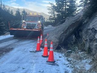
Seasonal closure in place for CO 82 Independence Pass through Spring 2025
Travel Advisory

Lake & Pitkin Counties — The Colorado Department of Transportation has closed Colorado Highway 82 Independence Pass, between Aspen and Leadville, for the 2024/2025 winter season effective immediately. CDOT originally closed the pass temporarily on Monday, Oct. 28, due to safety concerns surrounding winter weather conditions, but then extended the closure into the regular seasonal closure due to road damage from a recent rockfall near Mile Point 50 that required repairs and expected ongoing winter conditions.
During the seasonal closure, motorists can reach Aspen from the Denver Metro Area via westbound Interstate 70 to Glenwood Springs, then south on CO 82 to Aspen. Independence Pass closure gates will continue to be closed near Aspen and Twin Lakes until CDOT reopens the pass next spring, which is typically around the Memorial Day holiday weekend, weather permitting.
This annual seasonal closure is essential for ensuring the safety of maintenance equipment operators and the traveling public during winter. Plowing the steep switchbacks on CO 82 on either side of the pass is unsafe during the winter months, as certain sections of the roadway are at significant risk of avalanches.
Independence Pass Closure History
Independence Pass historically closes in November for the winter season. Dates for closures over the past ten years are:
2014 - Nov. 12
2015 - Nov. 4
2016 - Nov. 17
2017 - Nov. 17
2018 - Nov. 5
2019 - Oct. 28
2020 - Nov. 13
2021 - Oct. 28
2022 - Nov. 4
2023 - Oct. 30
Independence Pass is a Colorado Scenic and Historic Byway that is maintained by CDOT. It is the highest paved state highway in Colorado, crossing the Continental Divide at 12,095 feet. Although it is paved, the road is narrow and curvy in several sections, making it difficult to navigate in poor weather. Additionally, steep drop-offs are present along the route. Some areas of the roadway can only accommodate a single car width, so drivers must exercise caution and remain alert when facing oncoming traffic.
The summit of Independence Pass is located 18 miles west of Twin Lakes and 19 miles east of Aspen, crossing the Continental Divide over the Sawatch Range. The Pass travels through 32 miles of mountainous terrain, winding through the San Isabel National Forest on the east and White River National Forest on the west side of the Divide.
During the winter months, heavy snowfall at the highest elevations makes travel impossible. Independence Pass is typically open during the summer, from Memorial Day through November, depending on weather conditions.
Know Before You Go
Travelers are urged to “know before you go.” Gather information about weather forecasts and anticipated travel impacts and current road conditions prior to hitting the road. CDOT resources include:
- Road conditions and travel information: COtrip.org
- Download the COtrip Planner app: bit.ly/COtripapp
- Sign up for project or travel alerts: bit.ly/COnewsalerts
- See scheduled construction lane closures: bit.ly/laneclosures
- Connect with @ColoradoDOT on social media: Twitter, Facebook, Instagram and YouTube
Remember: Slow For The Cone Zone
The following tips are to help you stay safe while traveling through maintenance and construction work zones.
- Do not speed in work zones. Obey the posted speed limits.
- Stay Alert! Expect the unexpected.
- Watch for workers. Drive with caution.
- Don't change lanes unnecessarily.
- Avoid using mobile devices such as phones while driving in work zones.
- Turn on headlights so that workers and other drivers can see you.
- Be especially alert at night while driving in work zones.
- Expect delays, especially during peak travel times.
- Allow ample space between you and the car in front of you.
- Anticipate lane shifts and merge when directed to do so.
- Be patient!
Download the COtrip App!
The new free COtrip Planner mobile app was designed to meet the growing trend of information on mobile and tablet devices for the traveling public. The COtrip Planner app provides statewide, real-time traffic information, and works on mobile devices that operate on the iOS and Android platforms. Visit the Google Play Store (Android devices) or the Apple Store (iOS devices) to download!
