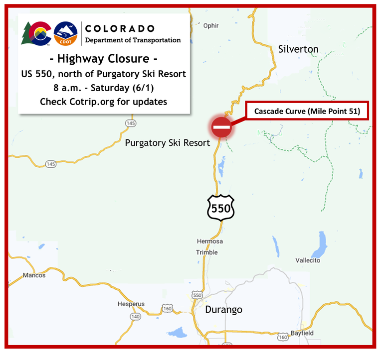
Crashed semi recovery operation to close US 550, north of Purgatory on Saturday
Travel Advisory

Southwest Colorado — US Highway 550, at Cascade Creek (Mile Point 51) will be closed Saturday morning, June 1 to allow for the recovery of a crashed semi truck. The road closure and recovery operation are scheduled for 8 a.m. and could last for most of the day. There is no exact time of reopening.
Travelers are encouraged to make it through the closure point, approximately 2 miles north of Purgatory Resort, before the hard closure time of 8 a.m. Motorists are urged to seek alternate routes and may consider the alternate route of CO 145, through Lizard Head Pass.
Northbound and southbound traffic will be stopped on either side of the crash site (Cascade Creek) located at Mile Point 51, approximately 26 miles north of Durango and 19 miles south of Silverton.
“Crews will work swiftly to perform the recovery and we may open the highway to one-way alternating traffic as soon as it is safe to do so,” said CDOT Maintenance Supervisor Vance Kelso.
Motorists are encouraged to check COtrip.org for the latest road closure updates.
On May 29, US 550 was closed from approximately 11:30 p.m. to 1:30 a.m. while emergency personnel responded to the scene of a semi truck hauling pipe that had gone off the roadway and into Cascade Creek. The truck remained at the crash site until a specialized heavy tow company was available.

Know Before You Go
Travelers are urged to “know before you go.” Gather information about weather forecasts and anticipated travel impacts and current road conditions prior to hitting the road. CDOT resources include:
- Road conditions and travel information: COtrip.org
- Download the COtrip Planner app: bit.ly/COtripapp
- Sign up for project or travel alerts: bit.ly/COnewsalerts
- See scheduled construction lane closures: bit.ly/laneclosures
- Connect with @ColoradoDOT on social media: Twitter, Facebook, Instagram and YouTube
Download the COtrip App!
The new free COtrip Planner mobile app was designed to meet the growing trend of information on mobile and tablet devices for the traveling public. The COtrip Planner app provides statewide, real-time traffic information, and works on mobile devices that operate on the iOS and Android platforms. Visit the Google Play Store (Android devices) or the Apple Store (iOS devices) to download!
