Severe winter weather to hit Colorado statewide Wednesday through Friday
Travel Alert
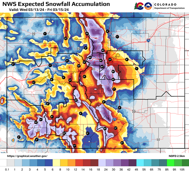
Statewide - A powerful spring storm that is forecasted to be measured in feet of snow is predicted to hit the Denver metro region and impact the mountains and much of the state. While Colorado Department of Transportation crews will be out in force to plow the roads, motorists are urged to avoid or limit travel during the worst of the storm, which is expected to begin late Wednesday and last through Friday. Even during periods when roads are warm and some snow melts, precipitation rates could be heavy during these periods, compromising visibility for drivers.
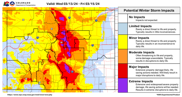
Road conditions will be treacherous across much of the state, with up to two feet of snow that could bury the I-70 mountain corridor from Golden to Vail and I-25 from Denver to northern Colorado Springs and US 285 from C-470 to Fairplay. Road closures along these corridors are anticipated for the safety of motorists. Travelers should anticipate delays due to winter maintenance operations, which will be necessary to keep the traveling public safe.
“It’s best to avoid driving on the roads during the height of the snow storm,” said CDOT Executive Director Shoshana Lew. “With snow expected to fall at a fast rate, visibility is likely to be compromised even during periods when snow is melting quickly. Warmer spring weather leading up to the storm also means that melting snow will freeze at night and contribute to slick conditions for travelers. Please use caution throughout this multi-day event.”
Avalanche dangers are expected in high elevations and on many of the mountain passes along roadways, including Loveland Pass, Berthoud Pass and possibly the West Loop Road and the Vail Narrows by I-70, the Grand Mesa and Monarch Pass. Motorists should be prepared for safety closures as CDOT and Colorado Avalanche Information Center crews conduct avalanche mitigation operations. Backcountry users should avoid these areas.
“We urge motorists to stay off the roads, but if you must go out, slow down and give yourself plenty of space between other drivers, said Col. Matthew C Packard, Chief of the Colorado State Patrol. “According to Colorado’s traction and chain law, all vehicles need to be prepared with adequate tires and equipment when traveling. If carrying chains or checking your tire tread seems like a hassle, imagine the inconvenience of being unable to climb up a pass or come to a stop on the other side, causing a crash.”
“Due to the amount of snow forecast through this storm, we have high confidence that avalanche mitigation operations will be needed Thursday through Friday,” said Mike Cooperstein, the Colorado Avalanche Information Center Northern Mountains Regional Manager. “Avoiding travel during peak periods of the storm is very important over the next few days for the safety of motorists. If you encounter avalanche debris across the highway, do not attempt to drive through the debris. Please call for help and stay in your vehicle.”
“The state’s emergency operations center is tracking this storm and will be prepared to offer additional support throughout this event,” said Colorado Department of Public Safety Executive Director Stan Hilkey. “In addition, we are ready to direct resources to support any local needs that arise as conditions become more challenging.”
Pavement will see a variety of impacts based on elevation, snowfall rates, and the time of day. The greatest mountain impacts are expected along and east of the northern/central Front Range beginning Wednesday afternoon, and also over the southern mountains beginning late Thursday. East of the Divide, the foothills and Palmer Divide will almost certainly bear the brunt, simply based on forecasted heavy snow and colder temperatures. The greatest complexity exists over the plains, where rain changes to snow Wednesday night. Residual heat should support melting and wet pavement during the initial phase early Wednesday night, before impacts develop by Thursday morning.
CDOT will continuously plow the interstates and other major roadways until the storm subsides, and then crews will plow state-maintained secondary roads with lower traffic volumes. This storm is expected to produce heavy wet snow, resulting in heavy snowpack on the roads by early Thursday morning and through the day and evening.
If motorists have to be out, they should plan ahead and check out the road conditions on COtrip.org and download the app. They should be prepared for extreme winter weather conditions and ensure their vehicles are equipped for heavy snow, including having the appropriate tires that will pass Traction Law requirements. Travelers are strongly encouraged to drive for the conditions including reducing speed and allowing for ample space between their car and the one ahead of them. They are also urged to NOT pass plows.
Motorists should be prepared for the chance of closures and pack extra blankets, clothing, food, water and entertainment. CDOT maintenance crews will be working diligently to clear the roadways of snow and ice until the roads are clear.


Statewide Impacts
Denver metro
The storm will start out as rain Wednesday afternoon and transition to snow by Wednesday night, with heavy wet snow expected through early Friday. Travel conditions will be especially difficult on Thursday, with 8 to 16 inches of snow forecast for the I-25 corridor. There will be snow packed roads with large amounts of snow built up on the ramps and shoulders throughout the region.
Northeastern Colorado
The North I-25 corridor to Wyoming is expected to start being impacted Wednesday evening. Total accumulations and snowfall rates look like roadways will be severely impacted through Thursday night. Northern mountains are looking to get hit hard also. Cameron Pass is expected to get 21 to 34 inches. Expect road closures and/or snow-packed roads.
I-70 Mountain Corridor from Golden to Vail
Motorists should be prepared for heavy snow and other winter driving conditions along the I-70 corridor, US 40 Berthoud Pass, US 40 Rabbit Ears Pass as well as CO 133 McClure Pass and CO 65 Grand Mesa. Safety closures and delays may be necessary for crews to safely conduct winter maintenance operations on these and other mountain passes in Northwest Colorado.
Southeastern Colorado
Heavy snow showers are expected late Wednesday through Thursday evening, especially along the I-25 corridor. Northern El Paso and Teller counties and areas south and west of Pueblo will see the most significant snow impacts. Motorists will encounter difficult road and weather conditions and should be prepared for safety closures needed for adverse conditions.
Southwestern Colorado
Steady snow showers are expected through the week and weekend for southwest and south-central mountains including the Sawatch, San Juan, and Sangre de Cristo mountain ranges. Motorists driving in the high country will encounter difficult road and weather conditions. Travelers should also be prepared for safety closures needed for adverse conditions or winter maintenance operations.
Winter Travel Tips for Motorists
- Avoid or limit driving during the brunt of the storm on Thursday.
- Work from home if you can.
- If you plan to travel, know before you go by checking out the latest weather conditions and visiting COtrip.org for road conditions (see info sources below).
- Make sure your vehicle is winter ready with the appropriate tires for the weather and have a snow emergency kit.
- Once you are out on the road, take it slow, no sudden stops and leave plenty of following distance.
- Give plows space! Stay back three to four car lengths from snow plows.
Safety Closures
A safety closure is a precaution taken during inclement weather to reduce the probability of traffic incidents, increased congestion or other safety-related factors. During a safety closure, traffic may be stopped on the interstate, turned around or directed to an exit. Safety closures help decrease delay times, and, above all, keep travelers safe.
Chain & Traction Laws
When weather conditions warrant, CDOT will activate the Traction Law. If weather conditions deteriorate, CDOT will activate Chain Laws for passenger and commercial vehicles. Motorists will be alerted to an active Traction or Chain Law by highway signage, COtrip.org and traffic/roadway condition alerts. For more information on the Traction Law and Passenger Vehicle Chain Law requirements, visit codot.gov/travel/winter-
COtrip.org & COtrip Planner App
If motorists must head out during this winter storm, they are urged to visit COtrip.org and download the COtrip Planner app ahead of time. Motorists are now able to sign up for travel alerts through COtrip.org to see if there are any highway closures or impacts along their favorite routes. The COtrip Planner app also offers a “Trip Planner” feature that allows motorists to map out their routes and receive updates about road closures or incidents along the way. Motorists can turn on the “Hands-Free, Eyes Free” feature to receive these alerts via voice notifications and avoid routes with impacts.
The free COtrip Planner mobile app was designed to meet the growing trend of information on mobile and tablet devices for the traveling public. The COtrip Planner app provides statewide, real-time traffic information, and works on mobile devices that operate on the iOS and Android platforms. Visit the Google Play Store (Android devices) or the Apple Store (iOS devices) to download!
Know Before You Go
Travelers are urged to “know before you go.” Gather information about weather forecasts and anticipated travel impacts and current road conditions prior to hitting the road. CDOT resources include:
- Road conditions and travel information: COtrip.org
- Download the COtrip Planner app: bit.ly/COtripapp
- Sign up for project or travel alerts: bit.ly/COnewsalerts
- See scheduled construction lane closures: bit.ly/laneclosures
- Connect with @ColoradoDOT on social media: Twitter, Facebook, Instagram and YouTube
