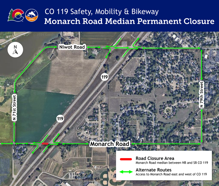
Monarch Road median between northbound and southbound CO 119/Diagonal Highway will close Jan. 3
Travel Advisory
Boulder County — The Colorado Department of Transportation and Contractor, Kraemer North America, will close and reconfigure the Monarch Road median between northbound and southbound Colorado Highway 119/Diagonal Highway on Friday, Jan. 3, for the CO 119 Safety, Mobility and Bikeway Improvements Project.
Crews will permanently close the current configuration of Monarch Road, in the median between northbound and southbound CO 119/Diagonal Highway, to all travelers and modes of transportation.
- Niwot Road will be available as an alternate route to access Monarch Road on the east or west side of CO 119.

Once the median portion is closed, Monarch Road at CO 119/Diagonal Highway will be reconstructed into a right-in/right-out intersection. Crews will also switch southbound CO 119 traffic onto new temporary pavement during this closure.
After carefully considering and reviewing the traffic crash data from the high number of severe crashes that have happened here, the project’s engineers and traffic staff, in partnership with Boulder County, ultimately decided to close the Monarch Road crossing at CO 119/Diagonal Highway. This closure is essential to constructing a safer CO 119 corridor for the community.
Work schedules are subject to change and can vary based on conditions.
What is the CO 119 Safety, Mobility and Bikeway Improvements Project?
By the year 2040, the Diagonal Highway between Boulder and Longmont is expected to see a 25% increase in vehicular traffic. Increased traffic can result in more congestion, delay, tailpipe emissions and potentially more crashes.
The CO 119 Safety, Mobility and Bikeway Project is constructing safety, mobility and bikeway improvements to make traveling through the corridor safer for all modes and transit travel faster and more reliable. The project is designed to integrate with other active multimodal projects on the corridor to ensure community members can safely and reliably travel throughout the corridor using their mode(s) of choice.
This project will:
- Improve safety in the whole corridor
- Maximize the number of people able to move through the corridor
- Maximize intersection operational efficiency
- Improve transit travel times and increase ridership
- Maximize corridor-wide operational efficiency
- Increase opportunities for bicycle commuting and connectivity to the bicycle and pedestrian network
Specific corridor improvements include:
- New signage, striping and improved signal timing at all pedestrian crossings at signalized intersections
- Signal timing adjustments at key intersections (Jay Road, 63rd Street, Colorado Highway 52, Niwot Road and Airport Road)
- Physically reconfiguring the CO 52 intersection to improve safety and to accommodate new Bus Rapid Transit stations and Boulder County’s Commuter Bikeway between the northbound and southbound travel lanes
- Changing access at Airport Road and CO 119 to reduce crashes and to improve safety and traffic flow
During construction, CO 119/Diagonal Highway will largely remain configured as it currently operates, with various lane shifts and closures. Additional notice information will be provided prior to any major closures or detour routes throughout the project duration. In addition, lane and shoulder widths will be minimized. The speed limit will be reduced. Please pay attention and follow posted speed limit signs. Kraemer North America is the General Contractor for this project.
CO 119 Safety, Mobility and Bikeway Improvements Project Contact Information
- Project phone line – 720-378-8083
- Project email – [email protected]
- Sign up for weekly project updates by following these steps:
- Visit the project website
- Select the "Stay Informed" box on the right side of the page
- From there, scroll to the "Construction Updates & News Releases" section and select "Subscribe to Construction Updates"
- Enter your email address, then select "Northeast Colorado" as the region, check "Front Range I-25 Corridor" and "CO 119 Safety & Mobility Improvements"
- Scroll to the bottom and select Submit
Know Before You Go
Travelers are urged to “know before you go.” Gather information about weather forecasts and anticipated travel impacts and current road conditions prior to hitting the road. CDOT resources include:
- Road conditions and travel information: COtrip.org
- Download the COtrip Planner app: bit.ly/COtripapp
- Sign up for project or travel alerts: bit.ly/COnewsalerts
- Check scheduled construction lane closures: bit.ly/laneclosures
- Connect with @ColoradoDOT on social media: Twitter, Facebook, Instagram and YouTube
Remember: Slow For The Cone Zone
The following tips are to help you stay safe while traveling through maintenance and construction work zones.
- Do not speed in work zones. Obey the posted speed limits.
- Stay Alert! Expect the unexpected.
- Watch for workers. Drive with caution.
- Don't change lanes unnecessarily.
- Avoid using mobile devices such as phones while driving in work zones.
- Turn on headlights so that workers and other drivers can see you.
- Be especially alert at night while driving in work zones.
- Expect delays, especially during peak travel times.
- Allow ample space between you and the car in front of you.
- Anticipate lane shifts and merge when directed to do so.
- Be patient!
Download the COtrip App!
The new free COtrip Planner mobile app was designed to meet the growing trend of information on mobile and tablet devices for the traveling public. The COtrip Planner app provides statewide, real-time traffic information, and works on mobile devices that operate on the iOS and Android platforms. Visit the Google Play Store (Android devices) or the Apple Store (iOS devices) to download!
