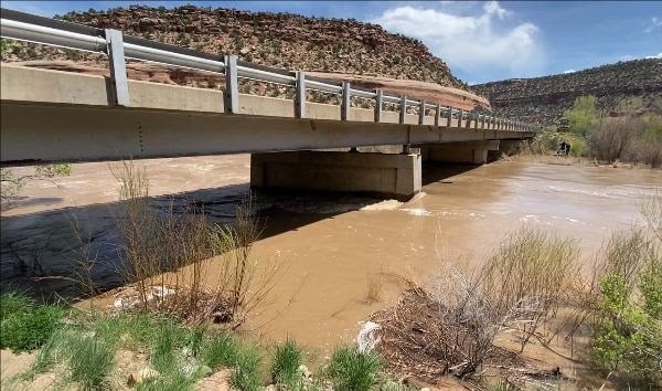
CO 141 between Naturita and Gateway to close for flood safety
Travel Advisory
Southwest Colorado — CO Highway 141 will likely be closed between Naturita and Gateway on Friday evening due to forecasted high river flows. If the river reaches expected levels, the Colorado Department of Transportation plans to close the highway at 5 p.m. The highway will remain closed until the flood danger has subsided. This closure is dependent on various factors including snowmelt and reservoir releases. The public will be alerted once the official closure is in place. As flow amounts fluctuate, the bridge may require additional closures.
“River flows in the area have not been observed at these levels in 18 years. With the flood event expected to peak this Friday, we are taking proactive and cautionary measures at this particular bridge. Engineers and maintenance personnel will be assessing the structural integrity throughout this high-flow event,” stated Julie Constan, Regional Transportation Director.
For safety, CDOT has determined that the bridge structure at Roc Creek should be closed to traffic while peak water flows are occurring. The structure is located approximately 27.5 miles north of Naturita at Mile Point 88.5.
The National Weather Service (NWS) has issued a flood advisory for the Dolores River due to the increased release of water from McPhee Reservoir. The flood advisory also includes the Dolores and San Miguel Rivers due to heavy runoff from snowmelt. The flood advisory is in place until further notice and covers the counties of Montezuma, Dolores, San Miguel and Montrose.
Traffic Impacts
Check COtrip.org for current road closures and conditions or contact Southwest Region 5 Customer Service during weekday business hours 970-385-1423.
- The northbound closure point is located just north of Naturita and the County Road CC junction, MP 64
- The southbound closure point is located just south of Gateway, MP 110
- Do not bypass the closure barricades

For more information about the flood advisory, refer to the National Weather Service Flood Advisory. For more information about McPhee Reservoir, visit the McPhee Water Release Update.
Know Before You Go
Travelers are urged to “know before you go.” Gather information about weather forecasts and anticipated travel impacts and current road conditions prior to hitting the road. CDOT resources include:
- Road conditions and travel information: COtrip.org
- Download the COtrip Planner app: bit.ly/COtripapp
- Sign up for project or travel alerts: bit.ly/COnewsalerts
- See scheduled construction lane closures: bit.ly/laneclosures
- Connect with @ColoradoDOT on social media: Twitter, Facebook, Instagram and YouTube
Remember: Slow For The Cone Zone
The following tips are to help you stay safe while traveling through maintenance and construction work zones.
- Do not speed in work zones. Obey the posted speed limits.
- Stay Alert! Expect the unexpected.
- Watch for workers. Drive with caution.
- Don't change lanes unnecessarily.
- Avoid using mobile devices such as phones while driving in work zones.
- Turn on headlights so that workers and other drivers can see you.
- Be especially alert at night while driving in work zones.
- Expect delays, especially during peak travel times.
- Allow ample space between you and the car in front of you.
- Anticipate lane shifts and merge when directed to do so.
- Be patient!
Download the COtrip App!
The new FREE COtrip Planner mobile app was designed to meet the growing trend of information on mobile and tablet devices for the traveling public. The COtrip Planner app provides statewide, real-time traffic information, and works on mobile devices that operate on the iOS and Android platforms. Visit the Google Play Store (Android devices) or the Apple Store (iOS devices) to download!
