Roadway and safety improvements to begin on US 550 south of Montrose
Travel Advisory
Montrose County — The Colorado Department of Transportation and contract partner Elam Construction of Grand Junction will begin roadway and safety improvements along US Highway 550 on January 30. CDOT and the project team will host an open house for the public on Wednesday, Jan. 25 from 4:30-6:30 p.m. at the Montrose County Event Center. The address of the event is 1036 North 7th Street. The general public and members of the public with access points along the highway corridor are encouraged to attend to learn about the phasing schedule and traffic impacts.
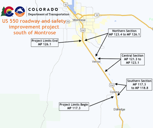
The project will take place at three locations along the 8.5-mile section of US 550. The project limits will begin at Otter Road south of Montrose, at Mile Point 126, and will continue to the Ouray-Montrose county line, at MP 117.5.

The US 550 corridor safety improvements include the following:
- Southern Section - County Line to Centennial RV Park, MP 117.3 to 118.8
- Deer fence, jump-outs and deer guards at each access
- Left-turn deceleration lane at Centennial RV Park
- Central Section - Uncompahgre Road to north of Trout Road, MP 121.3 to 123.1
- Trout Road intersection realignment
- Passing lanes at Trout Road
- Long left-turn lane from Tulare Road to north of Ridge View Drive
- Northern Section - south of Solar Road to Otter Road, MP 123.4 to 126.1
- Solar Road intersection realignment
- Solar Road left-turn deceleration lanes
- Long left-turn lane at Rose Road and Riverside Road
- Racine Road intersection realignment
- Full Length of Project - County Line to Otter Road, MP 117.3 to 126.1
- Access control
- Frontage road right-of-way fence
The new passing lanes will improve traffic flow and provide safer operational conditions while the auxiliary lanes will provide vehicles a safe path to decelerate to an appropriate speed before exiting the highway. The project is expected to last through October.
Other benefits of the project include a wildlife fencing system. Wildlife fencing keeps animals off the highway and directs them to safer crossing locations. When animals do enter the highway the new game ramps will allow access for animals to exit the highway corridor.
Traffic Impacts
Daytime work will take place Monday through Friday from 7 a.m. to 7 p.m. Motorists should plan for lane shifts, shoulder closures, one-lane alternating traffic, and a reduced speed limit throughout the work-zone.
Project Information
For additional information about this project:
- Call the project information line at: 970-456-1481
- Email the project team at: [email protected]
- Visit the project website at: https://www.codot.gov/projects/us550-otterroadsouth
Know Before You Go
Travelers are urged to “know before you go.” Gather information about weather forecasts and anticipated travel impacts and current road conditions prior to hitting the road. CDOT resources include:
- Road conditions and travel information: COtrip.org
- Download the COtrip Planner app: bit.ly/COtripapp
- Sign up for project or travel alerts: bit.ly/COnewsalerts
- See scheduled construction lane closures: bit.ly/laneclosures
- Connect with @ColoradoDOT on social media: Twitter, Facebook, Instagram and YouTube
Remember: Slow For The Cone Zone
The following tips are to help you stay safe while traveling through maintenance and construction work zones.
- Do not speed in work zones. Obey the posted speed limits.
- Stay Alert! Expect the unexpected.
- Watch for workers. Drive with caution.
- Don't change lanes unnecessarily.
- Avoid using mobile devices such as phones while driving in work zones.
- Turn on headlights so that workers and other drivers can see you.
- Be especially alert at night while driving in work zones.
- Expect delays, especially during peak travel times.
- Allow ample space between you and the car in front of you.
- Anticipate lane shifts and merge when directed to do so.
- Be patient!
Download the COtrip App!
The new FREE COtrip Planner mobile app was designed to meet the growing trend of information on mobile and tablet devices for the traveling public. The COtrip Planner app provides statewide, real-time traffic information, and works on mobile devices that operate on the iOS and Android platforms. Visit the Google Play Store (Android devices) or the Apple Store (iOS devices) to download!
