Summer 2022 planning guide: I-70 Mountain Corridor
Travel Advisory
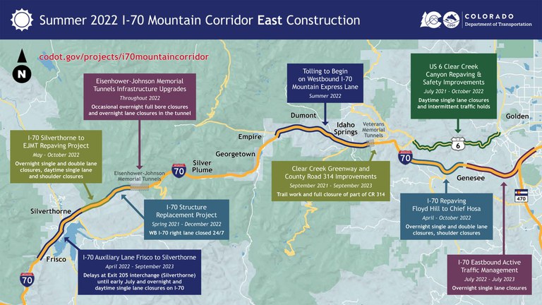
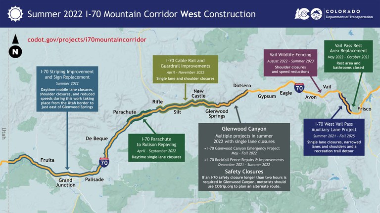
I-70 Mountain Corridor -The Interstate 70 Mountain Corridor between Denver and Grand Junction will have another busy construction season this spring and summer, into the fall, as the Colorado Department of Transportation is making numerous improvements to the corridor. Go to the I-70 Mountain Corridor page to see larger versions of the maps below.


“CDOT is going to be making a lot of much-needed safety and mobility improvements along the I-70 Mountain Corridor this summer, but drivers can be assured our teams have carefully coordinated across the state to minimize traffic impacts,” said CDOT Executive Director Shoshana Lew. “Still, summer travel through the high county on I-70 is always busy, so it is always best to plan ahead and be prepared for changing conditions.”
Because I-70 is so heavily used, and the weather conditions in the high country limit the time to do much of the upkeep work on the interstate, CDOT will conduct the work with the least impact as possible to motorists. Most of the lane closures on I-70 from C-470 to the Eisenhower Johnson Memorial Tunnel (EJMT) will occur overnight, with daytime work restricted to emergencies and shoulder closures. No lane closures are planned on weekends or holidays. There will also be daytime lane closures on nearby US 6 Clear Creek Canyon while the repaving and safety improvements continue on that stretch.
“If you are headed to the mountains from the Front Range, know before you go so you are prepared for the project work zones you might encounter along I-70 and parallel routes,” said Denver Metro Regional Transportation Director Jessica Myklebust. “From repaving and maintenance work, to adding technology along the corridor to improve travel times, CDOT is hard at work making the I-70 driving experience safer. Thank you for your patience during the summer construction season.”
Motorists heading into the high country should plan for additional travel time on I-70 in Summit County due to a series of roadway projects between Frisco and the Eisenhower-Johnson Memorial Tunnels. These projects will significantly improve safety in this popular and heavily traveled section of I-70. Traffic impacts before early July will be the greatest at the exit 205 interchange (Silverthorne) with US Highway 6 and Colorado Highway 9 (Blue River Parkway). Motorists should anticipate delays when accessing on-ramps for eastbound and westbound I-70. Starting in early July, traffic impacts at the exit 205 interchange will shift to I-70 and away from US 6 and CO 9.
“We’re excited to continue making significant safety improvements to I-70 on along the mountain corridor,” said Northwest Regional Transportation Director Jason Smith. “We appreciate your patience as crews improve and expand emergency access, resurface ruts and bumps into a smoother roadway surface, and install updated speed limit signs, guardrail and other infrastructure.”
CDOT encourages freight carriers to anticipate closures at the scenic overlook east of exit 203 (Frisco) and the Vail Pass Rest Area. The overlook near Frisco will remain closed during construction, but will reopen for the winter shutdown period.
The Vail Pass Rest Area will temporarily close starting May 2 for reconstruction of the rest area building and improved access roads and parking facilities. The new facility is designed to meet the high demand for services at the top of Vail Pass. Motorists should anticipate the rest area will remain closed through October 2023. Drivers will still be able to use exit 190 (Vail Pass), but there will not be restroom facilities available. CDOT encourages motorists to use other rest areas nearby, including the Gateway Visitor Center in Georgetown and the Edwards Rest Area in Edwards. Motorists should anticipate rest area closures in Glenwood Canyon if there is rain in the forecast.
Safety closures of I-70 in Glenwood Canyon will be necessary if there is a Flash Flood Warning for the area. If there is a safety closure on I-70 in Glenwood Canyon, and the closure is anticipated to last longer than two hours, motorists should use COtrip.org to plan an alternate route. CDOT recommends that travelers use the northern alternate route in most cases, which is Colorado Highway 9 to US Highway 40 to Colorado Highway 13. In the event of an extended I-70 Glenwood Canyon closure before early July, motorists using the northern alternate route should expect delays at the exit 205 (Silverthorne) interchange in Summit County. As mentioned above, construction work will mean delays for access to on-ramps to eastbound and westbound I-70. These delays will be complete in early July.
Motorists should be prepared for heavy traffic along the highly traveled mountain corridor during the busy summer season, give themselves some extra time to reach their destination, drive safely through work zones and check out COtrip.org for the latest road conditions.
Go to the I-70 Mountain Corridor project page for easy to read maps and the latest information on all of the projects.
- Access Summer 2022 I-70 Mountain Corridor Planning Guide
Know Before You Go
Travelers are urged to “know before you go.” Gather information about weather forecasts and anticipated travel impacts and current road conditions prior to hitting the road. CDOT resources include:
- Road conditions and travel information: COtrip.org
- Download the COtrip Planner app: bit.ly/3DYCDOH
- Sign up for project or travel alerts: bit.ly/COalerts
- See scheduled construction lane closures: bit.ly/3n9ZAI1
- Connect with @ColoradoDOT on social media: Twitter, Facebook, Instagram and YouTube.
Remember: Slow For The Cone Zone
The following tips are to help you stay safe while traveling through maintenance and construction work zones.
- Do not speed in work zones. Obey the posted speed limits.
- Stay Alert! Expect the unexpected.
- Watch for workers. Drive with caution.
- Don't change lanes unnecessarily.
- Avoid using mobile devices such as phones while driving in work zones.
- Turn on headlights so that workers and other drivers can see you.
- Be especially alert at night while driving in work zones.
- Expect delays, especially during peak travel times.
- Allow ample space between you and the car in front of you.
- Anticipate lane shifts and merge when directed to do so.
- Be patient!
Download the COtrip App!
The new FREE COtrip Planner mobile app was designed to meet the growing trend of information on mobile and tablet devices for the traveling public. The COtrip Planner app provides statewide, real-time traffic information, and works on mobile devices that operate on the iOS and Android platforms. Visit the Google Play Store (Android devices) or the Apple Store (iOS devices) to download!
