CDOT finalizes design for roadway and safety improvements on US 550 south of Montrose
News Release
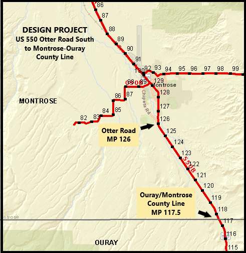
Montrose County — The Colorado Department of Transportation and consultant Muller Engineering are finalizing engineering designs for an 8.5-mile section of US Highway 550 south of Montrose. The project starts at Otter Road on the south edge of Montrose at Mile Point 126 and continues south to the Ouray-Montrose county line at MP 117.5. Once design work wraps up in late summer, CDOT can then advertise this corridor project to prospective highway construction contractors. Construction on the project is anticipated to begin in late 2022 and continue through spring 2024. The improvements will focus on safety and mobility.
CDOT is hosting an open house on Thursday, August 11, to present project information to affected property owners, commuters and local agencies. The event will take place from 4:30 p.m. to 6:30 p.m. at the Montrose Recreation Center at 16350 Woodgate Road. At the event, CDOT and Muller Engineering will present detailed information about the roadway and safety improvements along the corridor, answer questions, and gather contact information from those who would like to stay informed about future construction projects. The open house will also include a virtual option, with project information available on the project webpage and contact information for submitting questions.
“On this stretch of US 550, the number-one cause of accidents are collisions with wildlife, followed by rear-end and broadside collisions at intersections,” said Region 3 Transportation Director Jason Smith. “The design features wildlife fencing systems, passing and auxiliary lanes, and intersection realignments to improve safety along the project corridor.”
Specifically, the US 550 corridor design includes the following:
- Southern Section - County Line to Centennial RV Park, MP 117.3 to MP 118.8
- Deer fence, jump-outs and deer guards at each access
- Left-turn deceleration lane at Centennial RV Park
- Central Section - Uncompahgre Road to north of Trout Road, MP 121.3 to MP 123.1
- Trout Road intersection realignment
- Passing lanes at Trout Road
- Long left-turn lane from Tulare Road to north of Ridge View Drive
- Northern Section - south of Solar Road to Otter Road, MP 123.4 to 126.1
- Solar Road intersection realignment
- Solar Road left-turn deceleration lanes
- Long left-turn lane from Rose Road to Riverside Road
- Racine Road intersection realignment
- Full Length of Project - County Line to Otter Road, MP 117.3 to 126.1
- Access control
- Frontage road right-of-way fence
The wildlife fencing system will not only help keep animals out of the highway right of way, but the jump-outs (earthen one-way ramps) will allow animals to escape if trapped. Intersection realignments at Trout, Solar, and Racine roads will reconstruct these junctions to traditional T-intersections with 90-degree angles, giving motorists better sight distance when merging onto and off of US 550. Finally, passing lanes and auxiliary lanes will provide motorists with safer passing and merging opportunities.

Project Contact Information
The public is encouraged to contact the project to learn more about the planned work and potential impacts, and to sign up for project updates.
- Call the project information line at 970.783.0468
- Email the project team at: [email protected]
- Visit the project website at: https://www.codot.gov/projects/us550-otterroadsouth
