I-70 through Glenwood Canyon is closed due to Flash Flood Warning
Travel Advisory
Glenwood Springs - The Colorado Department of Transportation has closed Interstate 70 in both directions through Glenwood Canyon at mile points 133 (Dotsero) and MP 116 (Glenwood Springs) due to a Flash Flood Warning issued by the National Weather Service at 4:20 p.m. today, Wednesday, Aug. 18. The Flash Flood Warning is in effect until this evening. Motorists should plan on Glenwood Canyon being closed through the remainder of the Flash Flood Warning.
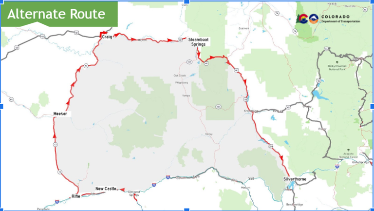
A traffic control point is in place at eastbound Exit 87 (West Rifle) to guide motorists to the northern alternate route (see map below).Visitors and local traffic traveling eastbound to Glenwood Springs and destinations in the Roaring Fork Valley can continue down US 6 and enter back on eastbound I-70 at Exit 90 (Main Rifle), Exit 97 (Silt) or Exit 105 (New Castle).
CDOT crews will continue to assess the burn scar area and will determine if it is safe to reopen when the Warning is lifted. In the event that a new mudslide occurs or a significant amount of debris from the mudslide path blocks the interstate, the closure may be extended past the Flash Flood Warning being lifted. Motorists should monitor COtrip.org for road closure information and continue to check the weather forecast before traveling in this area or through the mountains.
Traffic Impacts
-
Full closure of I-70 between Dotsero (MP 133) and Glenwood Springs (MP 116) - Motorists are strongly encouraged to use the recommended northern alternate route
-
Westbound motorists from the Denver metro area should exit I-70 at Exit 205 (Silverthorne) and travel north on Colorado Highway 9 towards Kremmling. Travelers will continue west on US Highway 40 and then south on CO 13 to complete the alternate route and return to westbound I-70 at Rifle (Exit 90).
-
Eastbound travelers can detour using the same route in reverse.

Encountering Inclement Weather
Heavy rains and summer storms can lead to challenging driving conditions. Colorado highways, particularly those in mountainous areas, can be vulnerable to the impacts of weather and the natural environment. It is important that the traveling public be aware of summer weather conditions and forecasts. Just as motorists prepare for driving in the winter time, during summer months, travelers should also be ready for heavy rain storms, hail storms and what can potentially occur after those storms – flooding, mudslides and falling rocks.
Why Closures are Needed
The safety of motorists is vital. When CDOT and the Colorado State Patrol determine that a road must be closed, the decision is made to protect everyone including motorists and response crews. The need for some closures is obvious – mudslides cover the highway, large boulders tumble onto the road, or a severe vehicle crash occurs.
If you are stuck in a closure waiting for a road to be cleared of mud or rocks, do not leave your car unless absolutely necessary. Never hang out in the grassy median located between lanes. If traffic is moving in the opposite direction, the median can be a hazardous area. Emergency response vehicles and heavy equipment may also need the median area to move about and access the emergency scene.
Be Prepared
Highway closures can last for as little as a few minutes or for as long as several hours. When drivers set out on a trip, especially through high country roads or the I-70 mountain corridor, it would be wise to have the car supplied with an emergency kit. The kit should contain at the very minimum: water, snacks, flashlight, and a blanket. Remember to also carry water for your pets if you’re traveling with animals. You may even consider packing some items to keep you or children occupied while waiting in the car. Activity books, colored pencils or a deck of cards can help pass the time.
Driver Safety
Heavy rains can cause flooding, mudslides and rock falls in regions downstream and on roadways adjacent to canyons, steep slopes or cliff walls. While I-70 through Glenwood Canyon will close well before there is a potential for flooding on the highway, motorists may drive up onto a flooded area on other mountainous roads and should follow the several precautions listed below:
- Never drive through any flooded area, you do not know how deep or how fast the water is running.
- Even 8-10 inches of water can float an average-sized car, which can be easily swept off the road.
- Driving too fast on wet roads or in flooded areas can cause a vehicle to hydroplane. Never use your cruise control during rainy conditions with standing water on the roadway.
- Any amount of flooding or mud can obstruct the roadway and hinder drivers from knowing exactly where to drive. If you cannot see the roadway, be smart and wait for the water to subside.
- Water and mud can contain unknown hazards hidden under the surface – rocks or other debris, like plant material and tree branches.
Know Before You Go
Travelers are urged to “know before you go.” Gather information about weather forecasts and anticipated travel impacts and current road conditions prior to hitting the road. CDOT resources include:
- CDOT safe driving tips: codot.gov/travel/driving-
safety and downloadable flyer - CDOT’s official and only road conditions website: COtrip.org
- CDOT project or travel alerts: bit.ly/COalerts
- CDOT social media: Twitter @coloradodot and Facebook facebook.com/coloradodot
- CSP impaired or aggressive driver hotline Dial: *CSP (*277)
- CSP social media: Twitter @CSP_News and Facebook facebook.com/
ColoradoStatePatrol - Tune in to your preferred weather source
