Ongoing closure of I-70 through Glenwood Canyon due to rapid shifts in the weather forecast
Travel Advisory
Glenwood Springs - The Colorado Department of Transportation closed Interstate 70 in both directions through Glenwood Canyon at mile points 133 (Dotsero) and MP 116 (Glenwood Springs) at 4:20 p.m. on Aug. 18 due to a Flash Flood Warning issued by the National Weather Service. The burn scar area in Glenwood Canyon has received significant precipitation since the closure last night, though no new mudslides or damage have been reported. The closure will remain in place due to an unusually high uncertainty with the forecast, including abrupt shifts this morning. The Flash Flood Watch in place now could turn into a Flash Flood Warning quickly.
While CDOT’s protocol for Glenwood Canyon since the mudslide in late July has been to close I-70 in the event that a Flash Flood Warning is issued, CDOT will continue to keep the Canyon closed out of an abundance of caution due to rapid shifts in the weather forecast this morning, combined with this being the first major weather event since the Canyon reopened. Safety continues to be CDOT’s number one priority.
Rain gauges throughout the area have already measured over an inch of rain in several locations. CDOT is following the same standard traffic safety and detour procedures that were in place during the previous closure. The repairs in Glenwood Canyon have held up through the weather event so far. This is the first significant rain event since the major slides occurred in late July, and CDOT is closely monitoring Glenwood Canyon to assess how the canyon responds to the rainfall and saturation.
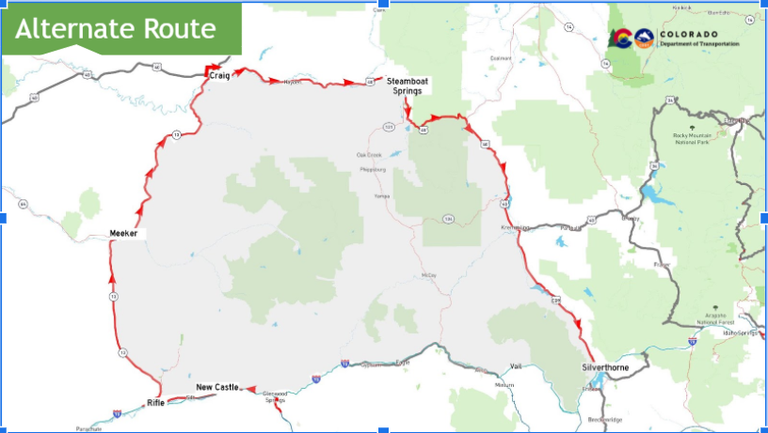
A traffic control point is still in place at eastbound Exit 87 (West Rifle) to guide motorists to the northern alternate route (see map below). Visitors and local traffic traveling eastbound to Glenwood Springs and destinations in the Roaring Fork Valley can continue down US 6 and enter back on eastbound I-70 at Exit 90 (Main Rifle), Exit 97 (Silt) or Exit 105 (New Castle).
CDOT crews will continue to assess the burn scar area and will determine if it is safe to reopen when the weather clears up. In the event that a new mudslide occurs or a significant amount of debris from the mudslide path blocks the interstate, the closure may become extended. Motorists should monitor COtrip.org for road closure information and continue to check the weather forecast before traveling in this area or through the mountains.
Traffic Impacts
-
Full closure of I-70 between Dotsero (MP 133) and Glenwood Springs (MP 116) - Motorists are strongly encouraged to use the recommended northern alternate route
-
Westbound motorists from the Denver metro area should exit I-70 at Exit 205 (Silverthorne) and travel north on Colorado Highway 9 towards Kremmling. Travelers will continue west on US Highway 40 and then south on CO 13 to complete the alternate route and return to westbound I-70 at Rifle (Exit 90).
-
Eastbound travelers can detour using the same route in reverse.

Know Before You Go
Travelers are urged to “know before you go.” Gather information about weather forecasts and anticipated travel impacts and current road conditions prior to hitting the road. CDOT resources include:
- CDOT website: codot.gov
- CDOT safe driving tips: www.codot.gov/travel/driving-
safety and downloadable flyer - CDOT’s official and only road conditions website: COtrip.org
- CDOT project or travel alerts: bit.ly/COalerts
- CDOT social media: Twitter @coloradodot and Facebook facebook.com/coloradodot
- CSP impaired or aggressive driver hotline Dial: *CSP (*277)
- CSP social media: Twitter @CSP_News and Facebook facebook.com/
ColoradoStatePatrol - Tune in to your preferred weather source
