March Storm Planning
Travel Advisory
COLORADO - The month of March typically means a lot of snow in Colorado. Colorado Department of Transportation crews are ramping up their response to the upcoming storms.
“Our team is preparing for these storms like we do any others,” said Shoshana Lew, CDOT executive director. “We want to encourage people to know the forecast before they travel and to be prepared for what could be some tough conditions in some areas of the state. If you need to drive, please be especially careful. Let plows keep the roads clear, make sure to move over for first responders, and be mindful that there are many trucks on the road working to restock stores across Colorado.”
WEATHER FORECASTS (as of Tuesday, March 17)
NORTHEAST COLORADO & METRO DENVER:
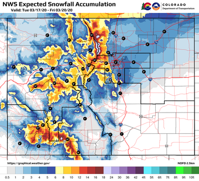
The main hit will be on Thursday with snow and blowing snow along the whole Front Range with accumulations of 2-5 inches in the Metro area and up to 7 inches to the north toward Wyoming. Blowing snow drifts could impact traffic to the eastern plains.
The heaviest impacts in the Metro area are expected to be along the foothills, including C-470 and CO 93. Floyd Hill and Conifer could receive up to 12 inches of snow on Thursday night.
I-25 SOUTH GAP:
The forecast calls for 6-10 inches Thursday night in the project area on I-25 from south of Denver to Monument. Motorists are urged to limit or avoid travel during the storm.
WESTERN SLOPE, NORTHWEST, SOUTHWEST & CENTRAL COLORADO:
Significant snowfall may develop over much of the high country Wednesday evening through Thursday afternoon. Roads are expected to be wet and slick during the day and transition to slushy to snow packed roads after dark on Wednesday evening, especially along high mountain passes and mountain corridors. Wednesday night could bring 8 - 12 inches on US 550 Coal Bank & Molas Passes and possibly higher accumulations on US 160 Wolf Creek Pass. On Thursday night, US 40 Berthoud Pass could see as much as 12 inches of snow and slightly less than a foot in the forecast for the Eisenhower Johnson Memorial Tunnel and Vail Pass. Light snow is likely to linger into the weekend.
SOUTHEAST COLORADO:
In the early hours of Wednesday morning, the I-25 Corridor will see rain and snow showers creating slick conditions for travelers. Wind and blowing snow will increase on Thursday causing low visibility, particularly along the US Highway 285 corridor in central Colorado, near Fairplay.

WHAT CDOT IS DOING
Across the state, where roads and highways are expected to be impacted by accumulating and blowing snow, maintenance crews have been assigned to ‘round-the-clock snow shifts beginning Wednesday evening. All available resources will be utilized. Road closures for safety reasons are possible depending on conditions.
WHAT MOTORISTS SHOULD DO
Due to colder temperatures throughout the duration of the storm, expect slick and icy conditions. Impacts are expected during Wednesday and Thursday. Conditions can be treacherous during the brunt of the storm, and CDOT urges motorists to limit driving while it is snowing. However, if you must drive during the storm, keep these tips in mind:
-
Drive slowly and reduce your speed.
-
Do not follow the car in front of you too closely.
-
Do not pass the plows.
-
Know before you go and take responsibility for your own safety. Check cotrip.org for the latest road conditions before heading out.
-
Make sure your car is prepared for winter conditions with the proper tires, a snow scraper, and other necessary items. Utilize this winter driving preparedness checklist for everything you need to have in your vehicle.
TRAVEL INFORMATION
Travelers are urged to “know before you go.” Gather information about weather forecasts and anticipated travel impacts and current road conditions prior to hitting the road. CDOT resources include:
-
CDOT road conditions and travel information: www.COtrip.org
-
CDOT travel alerts: bit.ly/COalerts
-
CDOT Social media: Twitter @coloradodot and Facebook facebook.com/coloradodot
